

The road grid system.... logical?
 Nov 9th 2012, 4:29 pm
#61
Bloody Yank

Joined: Oct 2005
Location: USA! USA!
Posts: 4,186


I'm American, and I'm only chortling slightly.
No, not really. There is no universal method used for street plans and numbering, and the systems can vary from perfectly sensible to confusing and absurd.
Some cities, er, address this quite logically. Chicago has it nailed -- there is a single center point which serves as the basis for N/S/E/W, and the numbering is completely consistent from block to block.
Then you have Manhattan, which does have a formula for assigning street numbers but is one of the most convoluted nonsensical things that you could hope to find. If you can figure this out, let me know, because I never have: http://www.bigapplevisitorscenter.com/gakmsts.htm
The types of anomalies describe in the OP tend to occur when cities failed to coordinate with each other. There is an example of this in Los Angeles with a particular street that has Beverly Hills on one side and LA on the other -- because Beverly Hills has its own numbering system for north-south streets, the addresses on the LA side of the street bear no resemblance to those across the road.
You'll just have to learn how things are done in your area. If you drive a lot for a living, then good maps combined with a GPS are probably a good idea.
 Nov 10th 2012, 1:02 am
#62
Banned
Joined: Feb 2012
Location: Purgatory (PU, USA)
Posts: 860
Driving over here is a pain in the arse, wider roads and all. Too many traffic lights, brainless drivers with no regard for safety and endless bottlenecks.
Nov 10th 2012, 2:16 am
#63
BE Enthusiast
Joined: Feb 2009
Location: Herts to CA for nearly 10 years and now MD
Posts: 351
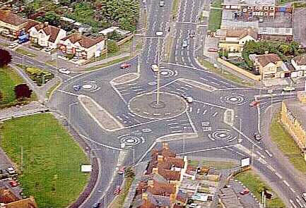
I wonder how many Americans would have a heart attack if they came across the Magic Roundabout in Hemel Hempstead. Even I had to pause and think about it the first time I had to drive round it. You can drive clockwise or anti clockwise
http://en.wikipedia.org/wiki/Magic_R...emel_Hempstead)
http://en.wikipedia.org/wiki/Magic_R...emel_Hempstead)
Nov 10th 2012, 4:36 am
#64
BE Forum Addict
Joined: Feb 2010
Location: Temecula, CA
Posts: 4,759
I wonder how many Americans would have a heart attack if they came across the Magic Roundabout in Hemel Hempstead. Even I had to pause and think about it the first time I had to drive round it. You can drive clockwise or anti clockwise
http://en.wikipedia.org/wiki/Magic_R...emel_Hempstead)
http://en.wikipedia.org/wiki/Magic_R...emel_Hempstead)
 Nov 10th 2012, 5:45 pm
#65
Lost in BE Cyberspace
Joined: Jan 2008
Posts: 41,518
I wonder how many Americans would have a heart attack if they came across the Magic Roundabout in Hemel Hempstead. Even I had to pause and think about it the first time I had to drive round it. You can drive clockwise or anti clockwise
http://en.wikipedia.org/wiki/Magic_R...emel_Hempstead)
http://en.wikipedia.org/wiki/Magic_R...emel_Hempstead)
 Nov 12th 2012, 1:39 am
#66
BE Forum Addict
Joined: Jun 2010
Posts: 2,847
Pah! Tis a mere walk in the park compared to Swindon's Magic Roundabout!
http://www.swindonweb.com/uploaded_f.../lifemagi1.jpg
http://www.swindonweb.com/uploaded_f.../lifemagi1.jpg
Nov 12th 2012, 11:34 pm
#67
BE Enthusiast
Joined: May 2004
Location: North Salt Lake, Utah
Posts: 318
If you find North Temple and State Street on a Google map of SLC - when North Temple has a green to go east and/or south by turning right onto State St, pedestrians are also crossing State St at the same intersection.
Nov 13th 2012, 1:37 am
#68
BE Forum Addict
Joined: Mar 2008
Location: Santa Cruz, CA
Posts: 4,913
I wonder how many Americans would have a heart attack if they came across the Magic Roundabout in Hemel Hempstead. Even I had to pause and think about it the first time I had to drive round it. You can drive clockwise or anti clockwise
http://en.wikipedia.org/wiki/Magic_R...emel_Hempstead)
http://en.wikipedia.org/wiki/Magic_R...emel_Hempstead)
 Nov 13th 2012, 1:41 am
#69
Banned
Joined: Feb 2012
Location: Purgatory (PU, USA)
Posts: 860
 Nov 13th 2012, 3:12 pm
#70
I approved this message
Joined: Dec 2004
Location: Chicago
Posts: 2,425
One thing that drives me nuts in Chicago is Interstate 55: it's due east-west in the entire Chicago area, yet labled as north-south (which makes sense, I know) . When I get out of Midway and want to head due west, I'm never sure if I need to get on 55N or 55S.
For your reading pleasure, a few interstate numbering scheme facts:
1. N-S is odd, E-W is even. Numbers get higher as you go north or east.
2. Main highways are two digits, secondary highways (beltways, spurs, alternates etc) are three digits.
3. Beltways and alternates around cities are generally numbered sequentially by the third digit depending on how far they are from the city center. E.G. the closest will be 195, next out 295, next out 395 etc. The last two digits of beltways are aligned to the primary "feeder" interstate.
4. Secondary interstates that will return to the primary feeder interstate are given an even first digit, ones with odd digits are spurs that will not return to the primary feeder. E.G. 495 will return to 95, 395 is a spur and will not.
5. Exit numbers are always sequential, but can be either ordinal (exit 1, exit 2 etc) or correspond to the nearest mile marker.
6. Mile markers on beltways are clockwise.
7. There are exceptions to all of the above rules.
8. The numbering system of the older US highway system is confusingly the exact opposite of the interstate system (higher as you go south or west). Also, there are so many exceptions that there are really no rules.
My favorite address scheme (yes, I have such a thing) is the one they use in the Florida keys. All addresses are given by mile marker on US 1. Since there is really only one linear road along the entire archipelago, it's extremely easy to figure out the relative placement of any address.
Last edited by Hiro11; Nov 13th 2012 at 3:15 pm.
Nov 13th 2012, 3:41 pm
#71
Member
Joined: Apr 2001
Posts: 14,049
Been gone long enough that I'd almost forgotten, but in many parts of New Jersey one describes where they live with their GSP or NJTpk exit number.
Regards, JEff
Regards, JEff
