

Major Infrastructure Projects in Penang.
 Mar 29th 2016, 2:05 am
#61
Forum Regular

Joined: Jul 2015
Location: Tanjung Tokong, Penang
Posts: 59


I was referring to the headgear the gent is wearing in the photo. Someone must have told him he has to wear a hard hat but not necessarily specified how.
 Mar 29th 2016, 5:47 am
#62
...............
Joined: Feb 2009
Location: Far North Queensland
Posts: 17,625
Just taken these snaps. Sorry they are a bit distant and fuzzy (a bit like me this morning) but think you can see the "boom" if that is what it is. I've heightened the colour a little bit too as it's a bit of a hazy day.
Mar 29th 2016, 9:17 am
#63
Hostage Negotiator
Joined: Jun 2013
Posts: 5,173
Another photo but hard to say what is going on:-
Mar 29th 2016, 10:00 am
#64
...............
Joined: Feb 2009
Location: Far North Queensland
Posts: 17,625
Your photo is clearer. Either you have a better camera than me, or you live in the sea.
Apr 3rd 2016, 3:28 am
#66
Hostage Negotiator
Joined: Jun 2013
Posts: 5,173
Thanks for that link SF. Unfortunately their server is very slow so it takes an age to navigate but I wonder how up to date their completion dates are as some of the documents are quite old.
Anyhow the booms in Gurney bay are growing every day, if I was a qualified engineer I might be able to figure out what is going on but it's a bit of a mystery so far. They seem to be, very roughly, where the new by-pass will be located.
Anyhow the booms in Gurney bay are growing every day, if I was a qualified engineer I might be able to figure out what is going on but it's a bit of a mystery so far. They seem to be, very roughly, where the new by-pass will be located.
Apr 3rd 2016, 5:34 am
#67
BE Enthusiast
Joined: Aug 2015
Location: Penang
Posts: 959
IVV I noticed the same thing: initially is the server quite slow (or they have heavy pictures on their home page). Browsing the other pages after the home page wasn't that bad though. The website was only launched this weekend, during some press event in KOMTAR. So the site is new, but that can not be said about its contents.
And yes, I do see the activities on the water every day. I'm not sure whether those activities are related to building the new island, or whether they want to keep the channel for commercial vessels deep enough.
And yes, I do see the activities on the water every day. I'm not sure whether those activities are related to building the new island, or whether they want to keep the channel for commercial vessels deep enough.
Apr 3rd 2016, 12:11 pm
#68
Forum Regular
Joined: Oct 2014
Location: Penang
Posts: 76
Very interesting link provided, as many of us live between Gurney / Batu Ferringhi area, I wonder how much of these routes shown on the maps are actually confirmed or are they still conceptual ?
On the previous forum there was a considerable amount of information but the routing then shown for various roads bye passes etc, was always pending final surveys, unless
I missed it there is no time frame shown for any completions.
In Batu Ferringhi there are two new developments both showing different routes for the intended B.F. bye pass ?
Apr 4th 2016, 11:36 am
#69
¿uo buıob s,ʇɐɥʍ
Joined: Jul 2013
Posts: 1,762
JC3
Apr 4th 2016, 1:30 pm
#70
Hostage Negotiator
Joined: Jun 2013
Posts: 5,173
https://www.google.co.uk/search?q=pu...D_NMK6fKfaM%3A
Apr 6th 2016, 2:06 am
#71
BE Enthusiast
Joined: Sep 2014
Location: Penang
Posts: 516
I think you are right since what I can see looks rather like this hydraulic dredge:-
https://www.google.co.uk/search?q=pu...D_NMK6fKfaM%3A
https://www.google.co.uk/search?q=pu...D_NMK6fKfaM%3A
Apr 7th 2016, 5:29 am
#72
Forum Regular
Joined: Mar 2015
Posts: 116
Don't know if this has been posted.
There is more here
Penang Property Talk
and here
Latest Projects Gallery | Penang Property Talk
Apr 7th 2016, 5:34 am
#73
Forum Regular
Joined: Mar 2015
Posts: 116
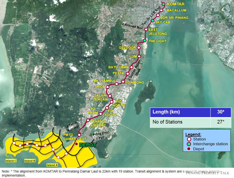
You can also see the new artificial islands, A, B and C of the south coast.
That's going to be nice
That's going to be nice
Apr 7th 2016, 10:08 am
#74
...............
Joined: Feb 2009
Location: Far North Queensland
Posts: 17,625
Just imagine all the disruption en-route to airport while this is being constructed (((sigh)))
Apr 15th 2016, 2:06 am
#75
...............
Joined: Feb 2009
Location: Far North Queensland
Posts: 17,625
There's some nice graphics on this new Penang Property link of:
1. The 3rd Link (undersea tunnel)
I had initially thought this was to be at t'other end of Gurney, but looks like (from the graphic) that it's halfway along.
Anyone want to stab a guess at exactly where?
2. The North Coastal paired road
This should really be of interest to anyone living in Tanjung Bungah or Bt Ferringhi.
I think we have all figured out now (haven't we?) where it's going. Seems to head off west at the L bend on the Maybank road, where that Indian shrine is currently located. Off into the hills and skirting the back of Miami Green. Then it's joining the bits of new roads up (think ManfromEmas figured that bit out).
Penang Third Link (Undersea Tunnel) | Penang Property Talk