

Interesting NZ/Europe map
 May 28th 2005, 9:43 pm
#1
Forum Regular

Thread Starter
Joined: Feb 2005
Location: Was Swindon now CHC
Posts: 36

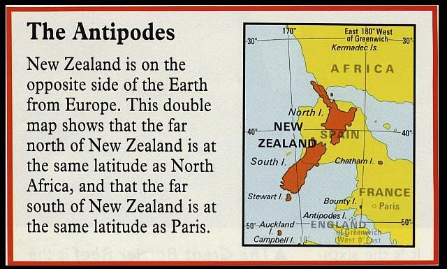
I was looking through my son's Children's Atlas and came across this picture of NZ superimposed on Europe (i.e. as if the globe had been flattened).
I thought it was quite interesting so have purloined it for your pleasure:
John.
PS To appease my guilt I'll list the publication:
Philip's Childrens Atlas by David and Jill Wright 1993 Reed International Books Limited ISBN 0 540 05723 1
I thought it was quite interesting so have purloined it for your pleasure:
John.
PS To appease my guilt I'll list the publication:
Philip's Childrens Atlas by David and Jill Wright 1993 Reed International Books Limited ISBN 0 540 05723 1
 May 28th 2005, 11:17 pm
#2
Account Closed
Joined: May 2005
Posts: 459

Hi
Very interesting. Its good to see that the authors consider Europe to be upsidedown and not NZ. I always knew that we'll be on top of the world when we get there
Very interesting. Its good to see that the authors consider Europe to be upsidedown and not NZ. I always knew that we'll be on top of the world when we get there
May 29th 2005, 10:11 am
#3
Guest
Posts: n/a
Over here in NZ they actually sell World maps with NZ at the top i.e. upside down  whoever decided what way up the world was anyway?
Mike
whoever decided what way up the world was anyway? Mike
