

Tropical Cyclone Owen - Northern Queensland
 Dec 1st 2018, 5:58 pm
#1
Home and Happy

Thread Starter
Joined: Dec 2002
Location: Keep true friends and puppets close, trust no-one else...
Posts: 93,814


TROPICAL CYCLONE INFORMATION BULLETIN
For 4:50 am EST on Sunday 2 December 2018 At 4 am AEST Sunday, a tropical low with central pressure 1000 hPa was located over the northern Coral Sea near latitude 12.8 south longitude 154.3 east, which is about 610 km northeast of Willis Island and 1030 km east northeast of Cairns.
The low is moving south at 9 kilometres per hour and is expected to deepen further, most likely developing into a tropical cyclone during the next 24 hours.
The system will continue drifting south until Monday afternoon or evening, and is then expected to turn and move slowly west. It is expected to intensify further during this time. However, this system poses no immediate threat to the Queensland coast, and should remain well off the coast until it weakens later in the week.
The next Information Bulletin will be issued by 11 am AEST today.
If named in Australian waters it will be called Owen.
Queensland Warnings Summary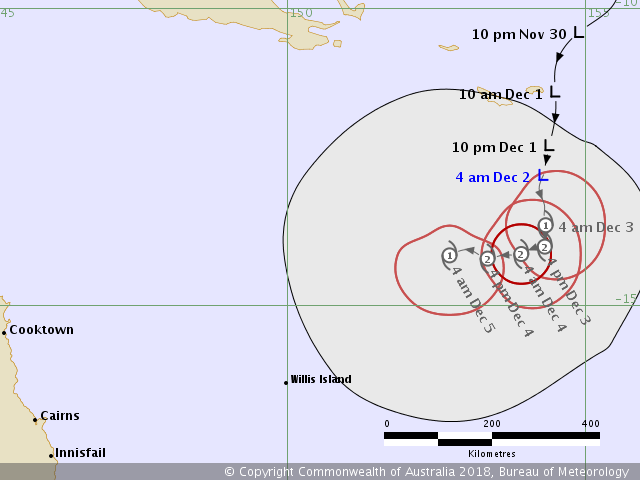
 Dec 2nd 2018, 3:56 pm
#2
Home and Happy
Thread Starter
Joined: Dec 2002
Location: Keep true friends and puppets close, trust no-one else...
Posts: 93,814
TROPICAL CYCLONE INFORMATION BULLETIN
For 10:45 pm EST on Sunday 2 December 2018
At 10 pm AEST Sunday, Tropical Cyclone Owen, category 1, with central pressure
995 hPa was located over the northern Coral Sea near latitude 14.4 south
longitude 154.7 east, which is about 550 km east northeast of Willis Island and
1000 km east northeast of Cairns.
Tropical cyclone Owen has continued moving slowly southeast during the past few
hours. Owen is expected to deepen further overnight and is likely to reach
Category 2 on Monday.
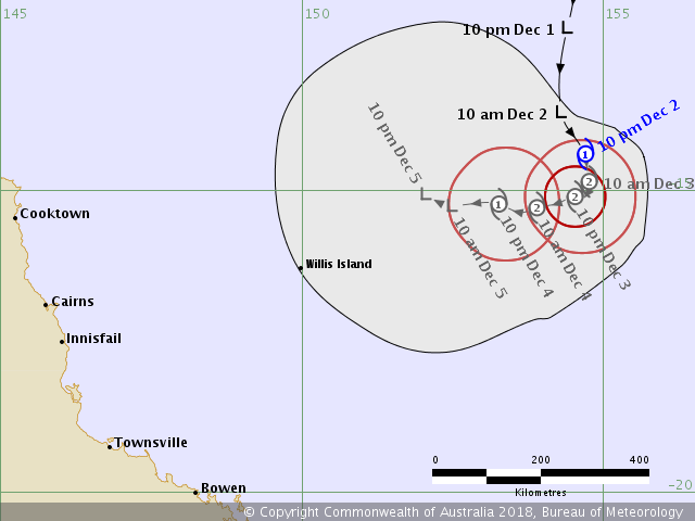
Tropical cyclone Owen is likely to turn southwestward on Monday and then more
westward on Tuesday. It should begin to weaken during Tuesday. The cyclone
should remain relatively slow moving, and poses no immediate threat to the
Queensland coast. It should remain well off the coast until it weakens later in
the week.
The next Information Bulletin will be issued by 5 am AEST today.
http://www.bom.gov.au/cyclone/?ref=ftr
For 10:45 pm EST on Sunday 2 December 2018
At 10 pm AEST Sunday, Tropical Cyclone Owen, category 1, with central pressure
995 hPa was located over the northern Coral Sea near latitude 14.4 south
longitude 154.7 east, which is about 550 km east northeast of Willis Island and
1000 km east northeast of Cairns.
Tropical cyclone Owen has continued moving slowly southeast during the past few
hours. Owen is expected to deepen further overnight and is likely to reach
Category 2 on Monday.
Tropical cyclone Owen is likely to turn southwestward on Monday and then more
westward on Tuesday. It should begin to weaken during Tuesday. The cyclone
should remain relatively slow moving, and poses no immediate threat to the
Queensland coast. It should remain well off the coast until it weakens later in
the week.
The next Information Bulletin will be issued by 5 am AEST today.
http://www.bom.gov.au/cyclone/?ref=ftr
Dec 4th 2018, 10:01 am
#3
Home and Happy
Thread Starter
Joined: Dec 2002
Location: Keep true friends and puppets close, trust no-one else...
Posts: 93,814
TROPICAL CYCLONE INFORMATION BULLETIN
For 1:46 pm EST on Tuesday 4 December 2018
At 1 pm AEST Tuesday, Ex-Tropical Cyclone Owen, with central pressure 998 hPa
was located over the Coral Sea near latitude 15.6 south longitude 154.9 east,
which is about 530 km east of Willis Island and 990 km east of Cairns.
Ex-tropical cyclone Owen has turned westward and weakened rapidly in the past 6
to 9 hours. Recent observations suggest the system has now weakened below
tropical cyclone intensity.
The remnants of ex-tropical cyclone Owen may continue to move west towards the
east tropical and/or central Queensland coasts later this week. This could
result in heavy rainfall developing about the central and east tropical coasts
late in the week, though there remains a large amount of uncertainty associated
with the movement of the system.
No further Tropical Cyclone Information Bulletins will be issued.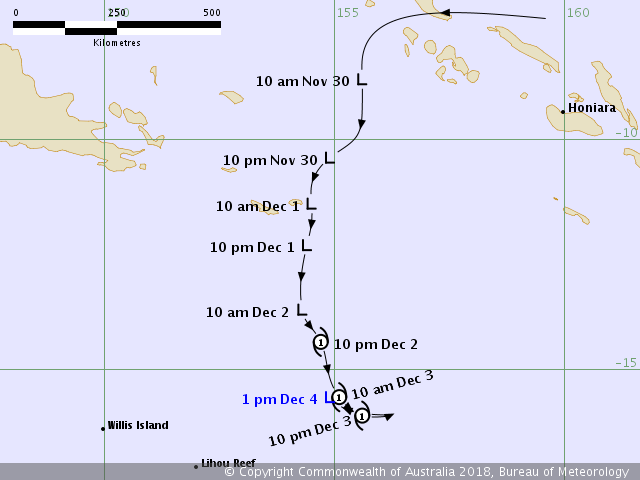
Dec 13th 2018, 4:17 pm
#4
Home and Happy
Thread Starter
Joined: Dec 2002
Location: Keep true friends and puppets close, trust no-one else...
Posts: 93,814
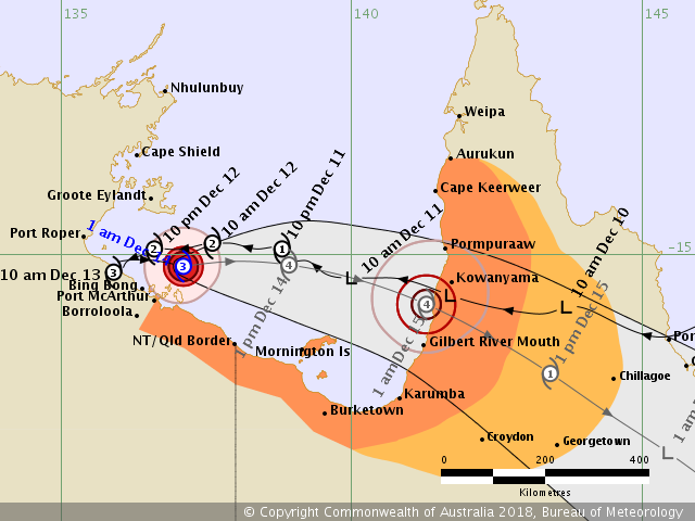
So having taken himself off into the Gulf of Carpentaria to have a think, Severe Tropical Cyclone Owen is now on his way back towards Queensland. Currently expected to cross the coast somewhere near Kowanyama late Friday, maybe as a Category 4 system. and then move down across Queensland, possibly as far as Mackay, but models are uncertain that far ahead.
This is a similar track to Tropical Cyclone Oswald in January 2013, which caused major flooding in many Queensland towns.
Possibly to be compounded by heavy rainfall moving onshore to the southeast of Queensland, could bring heavy rainfall to Brisbane and the southeast region over the next couple of days.
Severe Tropical Cyclone Owen is tracking slowly along the Northern Territory's north-east
coast, and is expected to batter a number of tiny communities and islands as it moves east towards Queensland.
Map of expected rainfall 14/12 - 17/12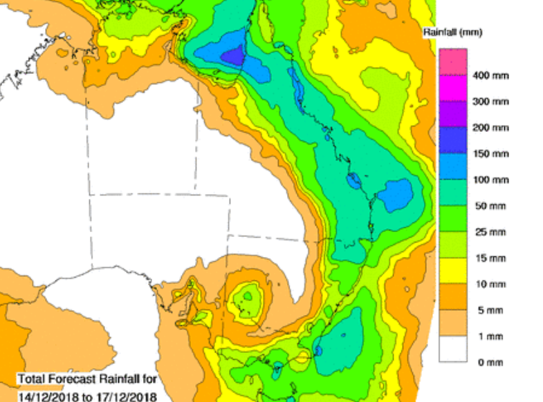
Last edited by Pollyana; Dec 13th 2018 at 4:25 pm.
Dec 13th 2018, 4:21 pm
#5
Home and Happy
Thread Starter
Joined: Dec 2002
Location: Keep true friends and puppets close, trust no-one else...
Posts: 93,814
TROPICAL CYCLONE ADVICE NUMBER 27
Issued at 1:52 am ACST [2:22 am AEST] on Friday 14 December 2018Severe Tropical Cyclone Owen will continue to move east over the southern Gulf of Carpentaria and strengthen.
Areas Affected:
Warning Zone Port McArthur in the Northern Territory, to Aurukun in Queensland, including Mornington Island, Karumba, Kowanyama and Pormpuraaw.
Watch Zone Extending inland from Karumba to Aurukun as far as Georgetown, Chillagoe and Coen.
Cancelled Zone None
Details of Severe Tropical Cyclone Owen at 12:30 am ACST [1:00 am AEST]:
Intensity: Category 3, sustained winds near the centre of 140 kilometres per hour with wind gusts to 195 kilometres per hour.Location: within 20 kilometres of 15.2 degrees South 137.1 degrees East, estimated to be 85 kilometres northeast of Port McArthur and 280 kilometres northwest of Mornington Island.
Movement: east southeast at 9 kilometres per hour.
Severe Tropical Cyclone Owen has recently moved east southeast parallel to the southwest Gulf of Carpentaria coast, but is expected to take a more easterly track during Friday morning. The system remains a category 3 system and is likely to continue to develop further over the next 12 to 24 hours as it moves east over open waters through a favourable environment. Severe TC Owen may reach Category 4 intensity early Friday.
A coastal crossing along the southeast Gulf of Carpentaria coast between Gilbert River Mouth to Pormpuraaw later Friday or early Saturday is likely, and there is a chance it crosses the coast as a category 4 system. Owen will then weaken as it moves southeastwards inland over the southern Cape York Peninsula.
Hazards:
VERY DESTRUCTIVE WINDS with gusts to 195 kilometres per hour are possible right near the centre. If Owen maintains intensity during Friday VERY DESTRUCTIVE winds are possible between Pormpuraaw and Gilbert River Mouth later on Friday or early Saturday. They may develop over Mornington Island during Friday afternoon if the system takes a more southerly track.
DESTRUCTIVE WINDS with gusts to 140 kilometres per hour are likely near the centre. They may develop over Mornington Island Friday morning and afternoon if the system takes a track further south. During Friday DESTRUCTIVE WINDS with gusts to 130 kilometres per hour may develop between Burketown and Cape Keerweer as the system approaches the Queensland coast.
GALES with gusts up to 110 kilometres per hour have been observed at Centre Island and may occur between Port McArthur and the NT/Qld Border early Friday morning. GALES may extend from the NT/Qld Border to Burketown Friday during the day, including Mornington Island, and then extend further to the southeast Gulf of Carpentaria between Burketown and Aurukun and adjacent inland areas late Friday and early Saturday.
HEAVY RAINFALL, which may lead to flash flooding, may occur about the islands and coastal areas of the southwestern Gulf of Carpentaria early Friday morning. HEAVY RAINFALL, which may lead to flash flooding is also likely across southern Cape York Peninsula later Friday and Saturday.
Tides may rise significantly above the normal high tide with DAMAGING WAVES and DANGEROUS FLOODING. From Port McArthur to Aurukun a STORM TIDE may develop and tides may rise significantly above the normal high tide, with DAMAGING WAVES and MINOR FLOODING.
Recommended Action:
The Territory Controller advises residents from Port McArthur to QLD/NT Border, A CYCLONE IS COMING:Residents from Port McArthur to NT/QLD border:
- Take Shelter as conditions deteriorate.
- Shelters are open in Borroloola.
- Move inside at home or to public shelters as winds and rain start.
- Communities need to be aware this event will extend ongoing.
Further advice on cyclone emergencies in the Northern Territory is available at www.securent.nt.gov.au
Please ensure that friends, family and neighbours have heard and understood this message, particularly new arrivals to the area.
People between the NT/Qld border and Aurukun, including Mornington Island, Karumba and Pormpuraaw, should immediately commence or continue preparations, especially securing boats and property [using available daylight hours/before nightfall].
People in areas inland from Karumba to Aurukun as far as Georgetown, Chillagoe and Coen should consider what action they will need to take if the cyclone threat increases.
- For cyclone preparedness and safety advice, visit Queensland's Disaster Management Services website (www.disaster.qld.gov.au)
- For emergency assistance call the Queensland State Emergency Service (SES) on 132 500 (for assistance with storm damage, rising flood water, fallen trees on buildings or roof damage).
Next Advice:
The next advice will be issued by 5:00 am ACST Friday 14 December [5:30 am AEST Friday 14 December].This advice is available on telephone NT-1300 659 211 and QLD-1300 659 212
A map showing the track of the cyclone is available at: Current Tropical Cyclones
Last edited by Pollyana; Dec 13th 2018 at 4:23 pm.
Dec 15th 2018, 12:25 am
#6
Home and Happy
Thread Starter
Joined: Dec 2002
Location: Keep true friends and puppets close, trust no-one else...
Posts: 93,814
TROPICAL CYCLONE ADVICE NUMBER 39
Issued at 10:55 am EST on Saturday 15 December 2018Headline:
Owen is moving inland over the northern interior of Queensland and weakening.Areas Affected:
Warning Zone
Inland areas of the northern interior of Queensland, including Croydon and Georgetown.Watch Zone
NoneCancelled Zone
Coastal areas between Karumba to Kowanyama.Details of Tropical Cyclone Owen at 10:00 am AEST:
Intensity: Category 1, sustained winds near the centre of 85 kilometres per hour with wind gusts to 120 kilometres per hour.Location: within 55 kilometres of 17.0 degrees South 142.6 degrees East, estimated to be 175 kilometres east northeast of Normanton and 175 kilometres northwest of Georgetown.
Movement: southeast at 22 kilometres per hour.
Tropical cyclone Owen crossed the southeast Gulf of Carpentaria coast between Kowanyama and the Gilbert River Mouth as a low-end Category 3 system at approximately 3am AEST this morning. It has since weakened to a category 1 system and is expected to track east southeast over the northern interior of Queensland today while weakening further.
Hazards:
GALES with gusts up to 120 kilometres per hour extend to about 60 kilometres from the centre of the system in the north, and to 90 kilometres from the centre in the south.Areas of heavy rainfall, which may lead to flash flooding, are occurring near the cyclone about the southeast Gulf Country district, and will extend eastwards across southern Cape York Peninsula as the cyclone moves inland during the day. Other areas of heavy rainfall are forecast to develop about the North Tropical Coast and Herbert and Lower Burdekin districts through the weekend. A Flood Watch is current for numerous catchments across northern and central Queensland and a Severe Weather Warning is also current.
Tropical Cyclone Advice 1 (QLD)
 Dec 15th 2018, 12:26 am
#7
Home and Happy
Thread Starter
Joined: Dec 2002
Location: Keep true friends and puppets close, trust no-one else...
Posts: 93,814
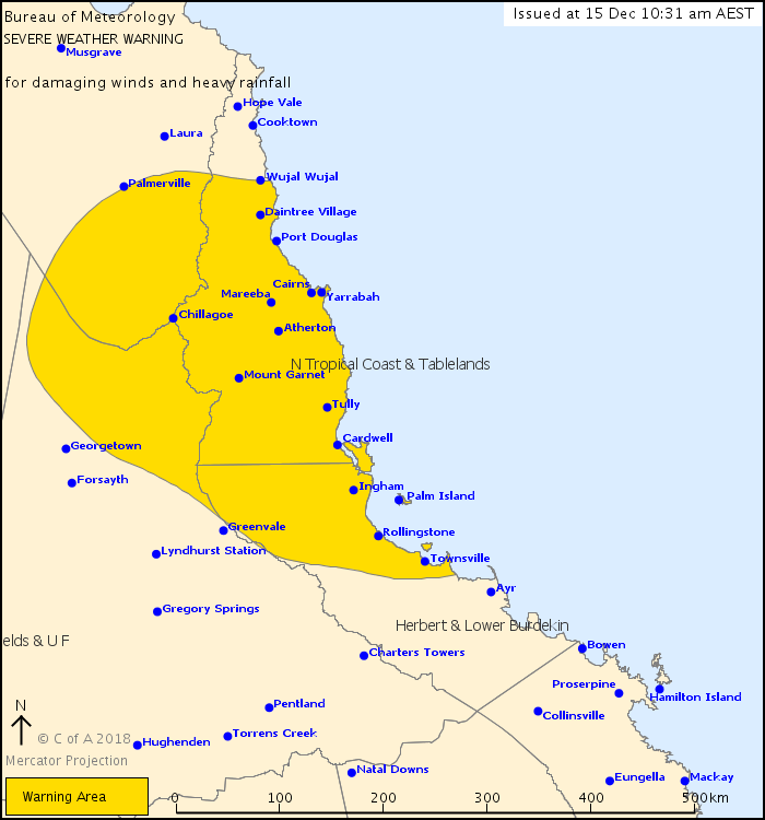
Severe Weather Warning
for DAMAGING WINDS and HEAVY RAINFALL
For people in North Tropical Coast and Tablelands and parts of Peninsula, Northern Goldfields and Upper Flinders and Herbert and Lower Burdekin Forecast Districts.
Issued at 10:31 am Saturday, 15 December 2018.
Tropical Cyclone Owen will move east over the northern interior today with heavy rainfall and damaging winds developing.
Weather Situation:
Tropical Cyclone Owen crossed the southeast Gulf of Carpentaria coast between Kowanyama and Gilbert River Mouth in the early hours of today. Tropical Cyclone Owen is expected to continue moving east southeastwards over the northern interior of Queensland through today while gradually transitioning to a tropical low.
Heavy rainfall, which may lead to flash flooding, is expected to develop over the warning area through this afternoon and evening. 6 hour totals of between 100-200mm are possible, particularly with thunderstorms. The heavy rainfall may persist into Sunday, particularly about the coast, as the system moves further east or southeast towards the Coral Sea.
Damaging winds, with peak gusts in excess of 90km/h, are likely near the system as it moves east over the northern interior during today, and may extend to the North Tropical Coast and Tablelands district through this afternoon and evening.
Damaging wind gusts will also be possible about the northern beaches of Cairns during Sunday morning.
There is some possibility the low will move offshore of the east tropical coast during Sunday. At this point the system is deemed to have a low to moderate chance of reforming off the east tropical coast during Sunday or Monday. The situation will be monitored carefully and tropical cyclone advisories issued if the risk increases.
Note a tropical cyclone warning remains current for the northern Gulf Country and southern parts of the Peninsula district.
Locations which may be affected include Chillagoe, Port Douglas, Cairns, Mareeba, Innisfail, Tully, Cardwell, Ingham, Palm Island and Townsville.
Queensland Fire and Emergency Services advises that people should:
* Move your car under cover or away from trees.
* Secure loose outdoor items.
* Seek shelter, preferably indoors and never under trees.
* Beware of fallen trees and powerlines.
* Never drive, walk or ride through flood waters. If it's flooded, forget it.
* Keep clear of creeks and storm drains.
* For emergency assistance contact the SES on 132 500.
The next Severe Weather Warning will be issued by 5:00 pm AEST Saturday.
Warnings are also available through TV and Radio broadcasts, the Bureau's website at Australia's official weather forecasts & weather radar - Bureau of Meteorology or call 1300 659 219. The Bureau and Queensland Fire and Emergency Services would appreciate warnings being broadcast regularly.
http://www.bom.gov.au/products/IDQ21037.shtml
